

Dynamic Earth Message
This is article about it how does it work that magnetic field of the Earth is changeable – north magnetic pole and south magnetic pole quickly wander and next they change their position for reverse one each other. About that how our planet expands – besides drift of its continents – with internal nuclear and thermonuclear powers. Why axis rotation of the globe increases in modern time when our terrestrial sphere gets bigger and bigger at the same time of the XXI century (instead of contrast situation that should be).
Motto:
If 50 millions believe in a fallacy, it is still a fallacy
– Samuel Warren Carey (1911 – 2002)
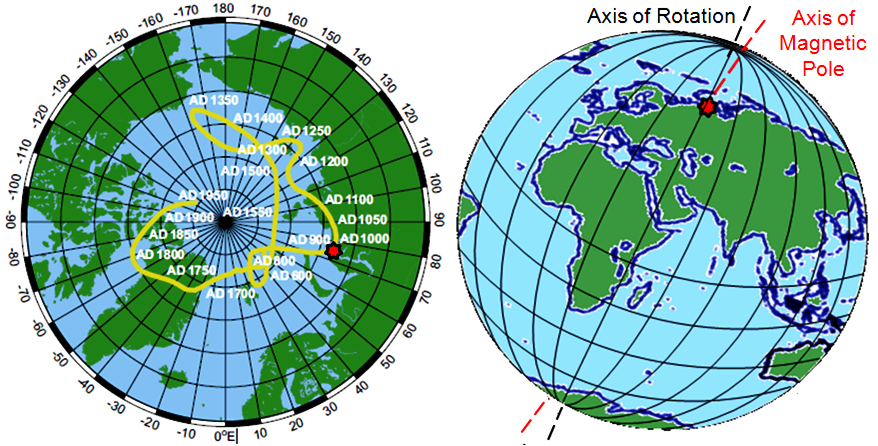
1. Alternating Magnetic Field NS SN
This is article about it how does it work that magnetic field of the Earth is changeable – north magnetic pole and south magnetic pole quickly wander and next they change their position for reverse one each other. About that how our planet expands – besides drift of its continents – with internal nuclear and thermonuclear powers. Why axis rotation of the globe increases in modern time when our terrestrial sphere gets bigger and bigger at the same time of the XXI century (instead of contrast situation that should be). It is my own ambitious independent theory based also on direct research in terrain of Warsaw in Europe (a dozen or so years of my measurements and analyses, in cosmos and terrain, starting from problems of global warming and energetics).
In field of the Earth sciences all of us are educated in universal scholarship knowledge system. We know that our globe is some pyramid (ball, of course) of stiff or melted down rocks and iron. But there is also alternative system of research knowledge treating about the Earth.
I accept plate tectonics theory and at the same vision expanding Earth theory. Both of them in this visualisation that is present on school globe model. More than four billions of years ago there were only continents on the surface of our planet – without the places for its oceans. From that time the Earth increased its surface area for three times and its inner volume for five times – with mechanism of nuclear and chemical reactions, as I believe. There is suggestion that it is also mechanism of thermonuclear synthesis reactions. Two atoms of silicon can give one atom of nickel and next of iron (Si + Si = {Ni} = Fe) in very high temperature of electric thunder runnings down in very dense inner gaseous plasma (20,000,000 atmospheres, 20,000 K) of the outer core georeactor. No solid and liquid states of matter are deep inside the globe, but sticky state (very sticky liquid state) and plasmatic gaseous (very dense and electric) state. This gaseous one – placed in the outer core of the planet – do not transmit transverse seismic waves (just gas with unconnected molecules) throughout its structure.
There is plasmatic electricity and also wandering and periodically changeable magnetism inside the Blue Planet. How is it possible in stable rocky pyramid?! No way ! The inner core of the Earth is moveable in relation to the mantle and the surface of the globe. It is like in ball bearing – where gaseous plasma is as many balls. This is why magnetic poles wander, meander, oscillate (each separately and together with other) around the Earth’s axis like the highest point of some internal spinning top (such children toy). In the second half of the XX century until the year 1973 the Earth decreased velocity of global rotation around its axis (as usual in a long geological time). After that year the planetary solid increases almost permanently this rotation speed. It is visible in trends of deviation of day length from SI based day (find: leap second). Diagram of this deviation has two distinct peaks and the third peak uncertain (incomplete). Such change of planetary rotation change trend in geological time is like some kind of lightning. Exactly! I expect that just before 1973 (maybe in 1964) there was electric thunder from friction in the zone placed near to plasmatic one of the globe. Big diametrical change in planetary rotation about this year is probably possible as due to some thermonuclear reactions transforming materials of the mantle (Si) to the core (Fe) of the planet as heavier and emitting up volcanic gases based on oxygen (O).
Increase of axis rotation for such giant spherical solid as the Earth is possible only in one case. When some big mass moves (here suddenly) down inside. It corresponds to physical principle of conservation of angular momentum. Then the inner core of the planet gets this mass. These facts accelerate rotation of mentioned mass on spiral trajectory following to the inner core. Then also this core accelerates as rotor. After such process turning speed of all the globe is faster than before, but speed of the inner core is faster than of the mantle and the crust. Then the north pole of planetary magnetic field is “over the globe”. In other case, when the inner core is slower than the mantle then the south magnetic pole of this field is “up” and the north magnetic pole is “under the globe”. The mantle increases its rotation when there is some revelantly big climatic cooling on the surface of the Earth and the planet at easier loses its internal heat throughout cleaner air and thinner cloudiness of the atmosphere. Then the Earth gets a bit smaller as cooler.
And how to slow down rotational move of still faster the inner core? In non-sceptic conception of mine our planet has in its center quite a bit of mass of uranium melted with iron and nickel. This element (“enriched” earlier) loses helons (decomposition and radiation with helium without electrons = alpha rays) and also neutrons (nuclear fission). So, it loses concentrated mass out and permanently in a long time slows when inner temperature does not increase (less of reactions). In very high temperatures neutrons and helons are needed to synthetic thermonuclear sporadic point reactions in thunders of gaseous georeactor zone of the Earth.
In my conception of nuclear and thermonuclear powered expanding Earth, generally, temperature of the planet center increases in billions and millions of years. The surface is more and more farther from this center. So, temperature on the planetary crust in a long time can decrease. When thermal transmission throughout the mantle and the crust increase (also throughout air and cloudiness in the atmosphere) then temperature inside increases slower or or even it decreases and then also inner pressure gets lower. Then there are less thermonuclear reaction incidents in plasmatic thunders (needing friction and highest temperatures). Then the inner core can slow down. Nowadays, due to material inertia of the sticky foam mantle all the globe spheric system increases its rotation. Above special “thermonuclear lecture” tells how expanding Earth – that should slow down having bigger volume – now speeds up. If the magnetic field had been conducted to change its north pole for the south pole (as reverse position) with someday far climatic cooling – this process has been now partially stopped.
It is only my hypothesis, but it tells finally how electric currents change periodically their direction inside the globe and magnetic field of our planet its walkable poles. The wondering great Blue Planet!
2. GPS Is Computational, Compensational and Virtual, not Inertially Based
Separate question is why systems based on satellite research – like GPS – falsify situation of planetary ground expansion (PGE) in modern times. In times of fast climate change, when global warming is placed on expanding Earth (interdependent phenomena).
Pilots in aircraft all over the world have for their use two kinds of altimeters. These are air-pressure altimeters and radar-radio altimeters. They still do not use GPS-satellite altimeters. Why? This is not only one inaccuracy of such satellite based system as GPS. Similar situation is in precise geodesy, but surveyors do not know this truth yet.
We can read about GPS altimeters in Wikipedia: “Global Positioning System (GPS) receivers can also determine altitude by trilateration with four or more satellites. In aircraft, altitude determined using autonomous GPS is not reliable enough to supersede the pressure altimeter without using some method of augmentation. In hiking and climbing, it is not uncommon to find that the altitude measured by GPS is off by as much as 400 feet depending on satellite orientation.[8]” [Altimeter / Wikipedia]
The Moon flies away from the centre of the Earth. Lunar Laser Ranging Experiment tells about it from many years. The Earth is not exactly homogenous in its gravity and not exactly spherical in its geometry. It has tide moves on its rigid crust. So, also satellites slowly fly away from the central point on their orbits with the same mechanism like the Moon. It is micro gravity assist (micro assist of gravitation, find: gravity assist).
Systems based on GPS satellites do not apply this phenomenon. They practice virtual compensation of their readings to constant dimension of the globe. Satellite systems are not based on solid inertial configuration but they are virtual. They rightly read position in geographic network but they wrongly count out distances between points on this network for millimeters and meters (etc.). System computes distances still for the net surface placed on stable level – lower for hundreds meters than real, dynamic one. They lie about expansionistic changes on our living and dynamic planet. Only classic measurements are reliable.
My terrain research in Warsaw found that Łazienkowski Bridge stood in place where in time of 41 years of this bridge exploitation extreme outer pillars on over 400-meters distance got farther from each other for about twelve centimeters (12 cm, near five inches). Instead of climatologically right dilatational balance temperature (DBT) resulting as normative in law in Warsaw for five degree Celsius (5 *C) the Łazienkowski Bridge (construction beginning: 1971) had in the year 2015 as many as 25 – 30 *C (twenty five – thirty) of new dilatation balance temperature (NDBT). Having stretched in time and space its plastic pipelines with gas and its cables with electricity, the Łazienkowski Bridge burned finally in February of the year 2015. Świętokrzyski Bridge in Warsaw (construction beginning: 1998) has now already 12 *C of NDBT, and Siekierkowski Bridge (opening: 2002) some 12 – 15 degrees in centigrade of this specific expansionistic bridge indicator. Road viaducts at Witosa Avenue in southern part of the city have already some 20 – 25 *C of NDBT. This is the key discover of my near scientific investigations.
Based on similar to GPS system, reference station research GNSS-ITRS says only about millimeter horizontal fluctuations (on and back) in Warsaw region, when in central and southern part of this Polish capital city ground expansion indicator measured under bridges and viaducts on their deeply anchored pillars exceeded 2 cm / km / yr (near one inch for kilometer in year). Except that now in Warsaw there are a lot of other effects of ground expansion, like crevices on many infirm buildings sliding partially long time on expanding sediments and first ones in tunnels having leaks of surface and underground water. More and more crevices in leaps in time, once here and next over there – what shows some seismic character of these expansionistic excess effects. Warsaw is placed on many geological layers of river sediments and sediment rocks (to 15 km down).
Adequate authorities in Poland give obstinately denial to walk into terrain to measure these facts. They tell only about GNSS or keep silent. They just levitate over reality among far cosmic satellites!
3. Is Mt. McKinley’s altitude right of PHGMetry, InSAR or GPS? And maybe global expansion is soon to be discovered?!
It is possible that planetary ground expansion powered fast nowadays by human industrial activity will be able to be discovered by world science with GPS in next few years, but researchers do not know about it yet. Measured in the year 1952 with photogrammetry method (surely airborne) Mount McKinley – now Mount Denali – had 20,320 feet of its altitude (height over sea level). Fifty years later in 2012 the mountain was measured again, then with use of interferometry InSAR (also aircraft version, new verdict in 2013). Next it was measured in 2015 with GPS satellite equipment. Mt. Denali – The High One (the name means) – measured with InSAR had 20,237 feet and measured with GPS had 20,310 ones (difference: 73 feet). It means that it was lower about 22 m by InSAR than by GPS (1 foot = 30.5 cm = 0.3 m). Does it mean something, if these measurements were carried out painstakingly?
Some forty meters is now approximately the scale of modern vertical Earth’s expansion in one year about 2015 in my analyses. On average maybe it is 27 m / yr in last thirty years. Now I estimate that the equatorial circumference of our planet got longer mainly in this time of XX and XXI century for one to ten kilometers (about 40,000 km plus 1 – 10 km). And then the globe radius got longer some 160 – 1,600 meters, of course. On the basis of the GRACE gravity satellite experiment and further its elaborations, I conclude that the surface of the Earth with its sea level and with tops of mountains fluctuates vertically in time of months or years in every given point for some forty meters (20 m up and 20 m down). These slow vertical moves of the planetary crust are caused by gravitational effects of internal mass concentrations and distractions in the georeactor inside the outer core – noted several years ago after the GRACE mission by French-German group of scientists.
Last year I discover that quantity of strong and strongest earthquakes (6 – 9.5 M in the Richter scale) increased on the world in last thirty three years for even 100 % in comparison to stable fluctuation trend running to about 1983, present in full USGS data existing from the year 1949 to 2016 (in packet of 5 or 15 years each, for 6 – 7 M, 7 – 8 M, 8 – 9.5 M). What does it means? It means that continental drift on the Earth accelerates now in essential manner. The same about planetary dynamics there tells increasing lava activity of indicator volcanoes (several eruptions in every century), on Hawaii and Sicily for example.
I am tempted by scenario, I guess that researchers used in 2012 in aircraft with InSAR device not barometric altimeter but GPS instrument. Very different result did worry they. So, three years later they used GPS equipment on the top of The High One mountain in Alaska. If we want really to know how it is tall, we need to repeat such measurements in near and far next years (my petition). Scientific experiments should be repeatable!
--------------------------------------
Samuel Warren Carey
https://pl.wikipedia.org/wiki/Samuel_Warren_Carey
Tectonica de expansion de la tierra... Samuel Warren Carey
https://elproyectomatriz.files.wordpress.com/2013/09/samuel.jpg
Expanding Earth
https://en.wikipedia.org/wiki/Expanding_Earth
Plate tectonics
https://en.wikipedia.org/wiki/Plate_tectonics
Magnetic field
https://en.wikipedia.org/wiki/Magnetic_field
Earth’s magnetic field
https://en.wikipedia.org/wiki/Earth%27s_magnetic_field
North Magnetic Pole
https://en.wikipedia.org/wiki/North_Magnetic_Pole
South Magnetic Pole
https://en.wikipedia.org/wiki/South_Magnetic_Pole
Magnetic Pole’s Wandering in Ancient Time
https://planetearth2017.files.wordpress.com/2012/05/figure-9-the-closer-...
The Spinning Top ( Snurretoppen ) / PamJohnGallo
https://www.youtube.com/watch?v=jdKzQixFN9U
Tippe Top - The Spinning Top that flips itself over when it is spun!
https://www.youtube.com/watch?v=ItuAtgvkIkM
Leap second
https://en.wikipedia.org/wiki/Leap_second
Deviation of day length from SI based day
https://upload.wikimedia.org/wikipedia/commons/5/5b/Deviation_of_day_len...
Angular momentum
https://en.wikipedia.org/wiki/Angular_momentum
Conservation of Angular Momentum / Bozeman Science
https://www.youtube.com/watch?v=hgcudPr73LU
Angular Momentum / NASA.gov Video
https://www.youtube.com/watch?v=2Oc-Ucx_4Ug
MIT Physics Demos: Conservation of Angular Momentum / MITK12Videos
https://www.youtube.com/watch?v=_XgYTP0kB7A
Climate change
https://en.wikipedia.org/wiki/Climate_change
Global warming
https://en.wikipedia.org/wiki/Global_warming
------------------------------------
Global Positioning System
https://en.wikipedia.org/wiki/Global_Positioning_System
Lunar Laser Ranging Experiment
https://en.wikipedia.org/wiki/Lunar_Laser_Ranging_experiment
Gravity assist
https://en.wikipedia.org/wiki/Gravity_assist
Łazienkowski Bridge
https://en.wikipedia.org/wiki/%C5%81azienkowski_Bridge
Warsaw’s Łazienkowski bridge up in flames
http://www.thenews.pl/1/9/Artykul/197087,Warsaw%E2%80%99s-Lazienkowski-b...
------------------------------------
Denali (Mount McKinley)
https://en.wikipedia.org/wiki/Denali
America’s tallest mountain a bit shorter
http://edition.cnn.com/2013/09/12/us/mount-mckinley-shrinks/
NASA Visible Earth: Same mountain, Different Measurements
https://visibleearth.nasa.gov/view.php?id=82133
Denali: Facts About North America’s Tallest Mountain
http://www.livescience.com/40595-denali-mount-mckinley.html
Denali is not just the new Mount McKinley – it’s also 10 feet shorter
https://www.theguardian.com/us-news/2015/sep/02/denali-elevation-new-data
Photogrammetry
https://en.wikipedia.org/wiki/Photogrammetry
Interferometric Synthetic Apreture Radar (InSAR)
https://en.wikipedia.org/wiki/Interferometric_synthetic_aperture_radar
Global Positioning System (GPS)
https://en.wikipedia.org/wiki/Global_Positioning_System
Medium Earth orbit
https://en.wikipedia.org/wiki/Medium_Earth_orbit
Altimeter
https://en.wikipedia.org/wiki/Altimeter
“JAPANESE SASAGO SYNDROME”, “DUTCH DAM MARKER” AND “AFRICAN INFERNAL OVERFLOW” AS EVIDENCES OF HOT EXPANDING EARTH THEORY [GLOBAL WARMING, GEOPHYSICS AND COSMOLOGY]
https://www.indymedia.nl/node/12313
Indila - Dernière Danse (Paul Damixie`s Private Remix)
https://www.youtube.com/watch?v=4w_7TfmvC6M